Approximate Location
OS Grid Reference: SJ 96978 69232
Latitude / Longitude: 53°13′12″N , 002°02′48″W
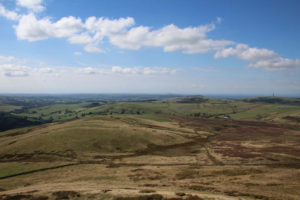
A stretch of open moorland lying to the south-west of Shuttlingslow. In Weirdstone, Chapter 20 – Shuttingslow, Susan was inspired to make a desperate dash across Piggford Moor after the fugitives were assailed by a flock of birds on the southern ridge of the hill. She spotted that the morthbrood and their allies were thinnest on the moor and set off to make an escape in that direction. The journey took the travellers downhill, across the moor and into the bed of a stream. The latter is un-named in the book, but was probably the Highmoor Brook.

Susan, Colin, Gowther, Fenodyree and Durathror then attempt an exhausted clamber up the slopes to the south-west of the stream. This hill is also un-named in the book, but maps reveal that it was Hammerton Knowl.

“Choking, they scrambled up the opposite hill. And that climb exhausted the last of their strength. It beat them mentally as well as physically, for it was a convex slope, and the skyline, the apparent top of the hill was always receding. It was never far away, but they could never reach it. Soon it was nearly beyond them to climb the stone walls that blocked their path, and when they did totter to the crest, and saw it was only a wide shelf, and that a further incline awaited them, all but Durathror collapsed as though their legs had been cut from under them.”
Garner, A., 1960 (1989 edition), The Weirdstone of Brisingamen. William Collins / Lions. London. p210-11.


Assailed by their enemies on this shelf, Durathror made a stand and slew the two remaining hounds of the Morrigan whilst Fenodyree led the others east towards Brown Hill and the Bullstones.